Click here to see the utica_oh.cad (338K) file
(You will need to install CadStd Lite or CadStd Pro before viewing)
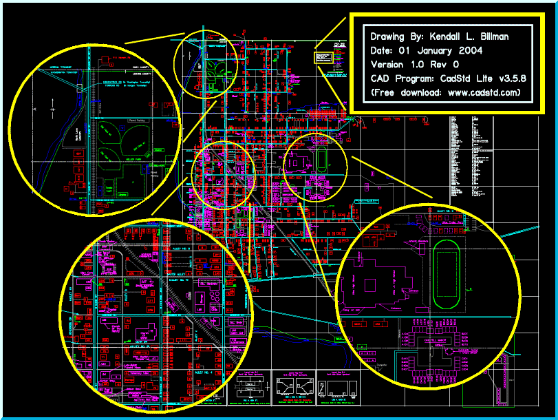
Utica Ohio
We were so impressed when Ken Billman sent us this map of Utica Ohio that he created using CadStd Lite that we decided it needed a special page. Ken is a Dispatcher for the village and created it in "approximately 4 months of walking the village and sketching out locations".
Click here to see the utica_oh.cad (338K) file
(You will need to install CadStd Lite or CadStd Pro before viewing)
Ken's Description of how the map is used:
The Dispatchers (which is my job with the village), use a printout that was made on cream colored card stock and taped together on the wall of the office. There were over 44 pages (8 x 11) in size taped together and it covers one whole wall. Dispatchers can then quickly look up an address and advise the Fire, Emergency Squad, and or Police that are responding to the scene exactly which house they are going to. Many houses either do not have the house numbers on them or they are not visible at night. Thus, we are able to tell them things like, it is the 3rd house on the right after you cross North Street. This gets them there immediately without delay. A copy of the lite version and the map file was also put on our dispatchers computer in order to put in updates and then print out the page that was changed so the update can be placed on the wall map.
For the Fire Department and Emergency Squads, I printed a reduced scale copy of the map and made it into a booklet form with tab numbers aligning the top and side grid letters and numbers. Thus, they are able to keep a copy of the map in their vehicles in case they might lose radio contact with the dispatchers. This allows them a way of still locating the address without any problems. The fire hydrant locations and numbers are on the map to aid the fire department in knowing ahead of time where the nearest hydrant is and enables them to know where they can refill the tanker trucks as well as connecting fire hoses directly to the hydrants. This also gives them a means to keep tract of "flushing" out the hydrants periodically. Both the Fire and Emergency squads have requested smaller copies of a wall map version for them to put in their offices. I am currently working on that also.
Currently, I am working on getting all the street lights onto the map with their pole numbers referenced. If you will look at the few I have already put on the northern part of the map, you will see my code number by them. My code was devised of using the Alphabetical Grid it is located in along with a number for the light in numerical sequence. Then my number is cross referenced to a database of the pole numbers. Thus, if they have the booklet pages set up of the map (like the ones in the vehicles), they can look at any light pole and know which map grid they are on. The dispatchers can look at the map when someone calls in a light not working and look the pole number up without sending someone out to get it. The pole number is needed when we call it into the electric company to get it fixed.
If you would like to contact Ken his e-mail address is: